- Home
- Live Blog
- Breaking News
- Top Headlines
- Cities
- NE News
- Sentinel Media
- Sports
- Education
- Jobs

OUR CORRESPONDENT
ITANAGAR: Residents of three remote districts in Arunachal Pradesh bordering China have drawn the attention of Prime Minister Narendra Modi to a proposed National Highway project that has been awaiting formal clearance since 2018.
The residents under the aegis of a committee in a letter to Modi, cited military advantage among other reasons on the road projects saying that once completed the road would significantly reduce the distance between the sensitive border region to the state capital Itanagar.
The letter, written by the Ziro-Tai-Anando Bagan Highway Committee (ZTABHC), comes within days after five people from Upper Subansiri district abducted by China's PLA and being handed back to India amid ongoing tension along the Indo-China border in eastern Ladakh since early this year.
The incident has brought into focus how vulnerable is the 1,129-km-stretch of McMahon Line - an imaginary boundary dividing Arunachal Pradesh from China's Tibet Autonomous Region.
China claims Arunachal Pradesh as part of South Tibet. In the 1962 Indo-China war, the state, including Upper Subansiri, was the theatre of action.
The letter draws the Prime Minister's attention towards the proposed 75-km National Highway from state's Meb-Geko to Gerukamukh-Gogamukh in Assam via Itanagar. The letter stated that the road, once built, would not only reduce the distance between Itanagar and the border districts of Upper Subansiri, Siang and Kamle, it would also ensure speedy movement of troops, heavy artillery and logistic support systems in the event of any national emergency.
ZTABHC chairman Larbin Nasi informed that the proposed highway was cleared in principle during 2017 and a final feasibility report was cleared in 2018. However, the project has since awaited formal clearance.
"The proposed highway also bring down the distance between Daporijo, the headquarters of Upper Subansiri district to Itanagar to 190-km," Nasi said, adding Daporijo is just 200-km away from Indo-China border. The existing Daporijo-Itanagar Road via Ziro is 335-km and the alternative route via Basar-Likabali is 375-km.
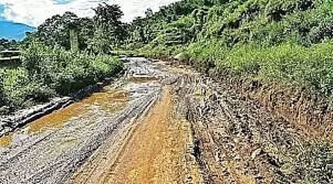
"Both these roads have remained in a deplorable condition since they were taken over in 2019 by the Ministry of Road Transport and Highways from the Border Roads Organisation," the letter said.
Talking about the military implications of bad connectivity, Nasi said the proposed highway would be helpful as 'border posts under the control of the Indian Army are reportedly under serious threat now'.
"The Chinese have reportedly built massive infrastructure near these posts - Sera-1 to Sera-9 - whereas there is no road on the Indian side," the letter stated.
According to Indian Army, the area under these three districts is among the remotest and most treacherous along the McMahon line in Arunachal Pradesh, which has not seen any major conflict since the 1962 war.
It takes the Army and ITBP jawans deputed here more than a week's trek - through extremely dense high-altitude jungles - to carry out their regular long-range patrolling with the help of local porters and guides.
"If these posts are captured by China, PLA will be in an advantageous position because of their heights. As such, the threat of intrusion by PLA is imminent and is all the more vulnerable now with porous international border. The construction of this highway has become all the more relevant and urgent in view of current border conflict," Nasi added.
Also Watch: Domestic Helps Demand Pension, Medical Insurance